
I don't know what my aversion is to saying I will keep a blog, then actually KEEPING said blog.
We are presently at a friend's vacation cabin near Bigfork, Montana, on Swan Lake (a smaller sister lake to Flathead Lake). A lot has happened since Minnesota - celebrated my birthday with hurricane-force winds in the Badlands of South Dakota, decided that we weren't doing the Black Hills any justice and skipped up to North Dakota earlier than anticipated, flew across eastern Montana to Great Falls, helped my friends at Malmstom Air Force Base pack and clean their house, then came here to Bigfork.
Writing is hard. I have found it exceedingly difficult for a number of years now. I don't know what it is that prevents me from being as prolific as I was in high school and the first half of college.
But either way, we're here. I rode a jet-ski for the first time yesterday and broke my toe in the process. (I'm a toe-breaker, if you haven't figured that out yet.) This may preclude me from doing much (any) backpacking in Glacier National Park, which is pretty much bullshit - but I am trying to keep my hopes up that my toe will feel great in the morning and will no longer be that ugly red-purple color in a few hours. (Shhh. Don't bust my bubble.)
We aren't sure what our plans are from this point out. We are definitely doing Glacier, Yellowstone and the Tetons, but after that - who knows. We would love to head out to the Pacific Northwest, but Patrick wants to get back to Knoxville to spend time with his kids and figure out his own future, and I'd also like to get back to Santa Fe because my sublettor (who is committed to Nov. 15) said that, if possible, he'd like to move out sooner. He's been a great sublettor so I'd like to help him out with that if I can. Before anything happens, though, we will have to head back to New Jersey to pick up Pat's car and my dog. Then there's always the question of, once I return to Santa Fe, what I will do for money and whether Patrick will eventually follow me out there.
Lots of things are up in the air. But right now I'm just looking out at the storm clouds moving over the lake, wishing I had the energy to write more, but all I really want to do is start reading a new book (finished one today) and eventually take a nap under some down comforters.
Sunday, August 22, 2010
Monday, August 2, 2010
Un-Home
Reporting from a McDonald's in Pipestone, Minnesota. We've spent a few nice days in the Midwest among some of the nicest people in the world. It's true, what they say.
After leaving the UP of Michigan, we went to Patrick's uncle's house in Stevens Point, Wisconsin. Patrick lived for a few years in Stevens Point around the time he first got married, so we drove around time figuring out what was still there after the 15 years since he lived there (and the 10 years since he last visited) and what was long gone. We hung out for a while with his uncle Joe (not to mention his dogs, a lab named Brandy and a truly massive one-year-old Great Dane named Rascal) and his family, and he then informed us that he'd intended to put us up in his stepdaughter's room - but said stepdaughter had come home for an impromptu visit, so he'd like to put us up in a hotel if we wouldn't mind.
Of course we wouldn't mind. So there we were, two nights in a row in a real live hotel. It was pretty much the best ever. I love camping and all, but having our very own bathroom only inches from where we were sleeping? Truly fantastic.
Our stop in Stevens Point mostly consisted of running some necessary errands, eating at Belt's Ice Cream (the "large cone" there is seriously as tall as your forearm and weighs about 4 pounds), drinking at Morey's (where Patrick celebrated either his 21 or 22 birthday - couldn't precisely remember), having a fish fry, drinking Point beer, and various other things that Patrick wants to do one more time in his life. He told me he likes the town, but probably won't be back. You know how ghosts can be.
We bade farewell to Wisconsin and made it to southern Minnesota by Saturday night. We camped the night on Saturday, July 28 in Lake Louise State Park, and last night got to Split Rock Creek State Park on the west end. In between we visited the Spam Museum in Austin, Minnesota - which, dare I say, is the coolest museum we've hit on this trip so far, not to mention it was free - the Jolly Green Giant in Blue Earth, Minnesota (not to mention Sprout at the nearby gas station), and the highest point in Iowa, which is just south of the Minnesota border. The highest point in Iowa is just a little hollowed-out clearing in a cornfield marked with a rock. But there's another high point we can cross off our bucket list! (While we were in Wisconsin, we also scaled Timm's Hill, the highest point in that state.)
At this point we are basically just desperate to get West - and while we crossed the Mississippi two days ago, Minnesota doesn't really feel like it counts. Today we'll finally get over to South Dakota (after we hit Pipestone National Monument in a few minutes), where I feel like the West will finally begin.
Sometimes I like the feeling of not-belonging; like no one place can claim me fully. Home is not home, nor is anywhere else decidedly un-home.
Gitche Gumee
At this point in my life, I have seen all five Great Lakes - though admittedly only the tiny piece of Huron visible as you cross the Mackinac Bridge - and have swam in three of them (Ontario, Michigan and Superior). I've talked a bit before about how great they are, and nothing made me fall in love more than Pictured Rocks National Lakeshore.
Our first full day at Pictured Rocks National Lakeshore, which fell on July 27, we spent mostly driving from site to site, seeing as much as we could. We are based on the west side of the park, and unfortunately, part of the main road through the park is closed (the park stretches about 40 miles along the coast of Lake Superior, from Munising to Grand Marais ). The only way to get to sites on the eastern end of the park is to go way out of the way on a gravel road and approach them from the east. As a result, we put about 200 miles on the car the first day we were there.
In the UP, we seriously got more brochures and maps from various businesses and tourist stops than we have at any location on this trip. The problem, however, is that the information that is on one map may not be on another, but the other map has other information we need - so we ended up shifting mostly between three different maps: One an index of waterfalls and lighthouses in the area; one a forest service map of Hiawatha National Forest and the state forests in the area; and one a map of Pictured Rocks itself. We managed to make sense of it all, however, and spent most of the first day checking out waterfalls all over the park and amassing passport cancellations at various visitors' centers.
The main attraction at Pictured Rocks are the incredible sandstone cliffs on Lake Superior, which often include fantastic wind-swept and ice-carved pillar and arch formations along the shore. The best way, supposedly, to see much of the cliffs is to take a boat ride down the coast - and in Munising, there are also glass-bottom boat tours of shipwrecks, which I think sounds like pretty much the coolest thing in history. But since we're doing this on a budget, we had to skip that. We loved the UP and Pictured Rocks, though, so we plan on going back eventually - and maybe we'll have money that time. Who knows.
Pictured Rocks also had a large dune much like the Lake Michigan Overlook dune at Sleeping Bear Dunes National Lakeshore - the incredible sand cliff dropping 450 feet to the lake - called the Log Slide. It was apparently precisely that in the days that the UP was a logging hot spot - the workers would slide the logs down into the lake. The dune had more vegetation at Pictured Rocks, however, so it didn't have this terrifyingly steep crazy sand-cliff effect like the one at Sleeping Bear did. This one was more like a narrow flume going straight down.
Near the Log Slide (about two miles away) is the Au Sable Lighthouse, which is only accessible by trail; there is no road leading there. It's one of the most remote, isolated mainland lighthouses in the US, and I was really interested in getting out there. They even have ranger tours for much of the week. Unfortunately, it was getting late by the time we finally got there on the 27, and if we'd wanted to go back on the 28, we would burn up a ton of gas in the car going out of our way to get there. So we had to leave Au Sable for the next time too.
Our best time in Pictured Rocks, however, happened the next day, which we dedicated to a hike to Chapel Rock. The trail leads to a waterfall about 1.5 miles into the woods, and then another 1.5 miles past there brings you to Chapel Beach and Chapel Rock itself. Patrick was mostly just desperate to get on a trail and do some real hiking, so we chose the hike mostly because it was there - but what we ended up finding was one of our favorite wilderness spots thus far.
We got a relatively early start, hitting the trail at about 10:30 am. It was supposed to be a cool day, in the 70s, whereas the previous day had been in the 80s, so we figured it would be the perfect day for walking. We got to Chapel Falls, which was pretty and all, but you can only see so many waterfalls in one week. The Pictured Rocks area has almost 20, and while we didn't see them all, we saw a lot.
Once we got past the falls, the trail started slowly descending, and by the time we got near the beach it was a sharp drop-off of about 100 feet where you have to climb down roots and rocks to get to the lake level. When we reached Chapel Rock, it was really impressive. It was a pillar like we'd seen at Miners Castle, but it had a full-grown tree on top of it! Just West of the rock was a large outlet from the woods where the creek we'd seen rushing over Chapel Falls finally reached the lake. It flowed into a large brown tidepool on the beach which was sometimes breached by waves from the lake, but flowed a little to the east and eventually joined in with the lake.
This day, the waves were particularly impressive, probably cresting at 6 to 8 feet! Not only were they large, but as they crashed into the sheer rock face that made up the area around Chapel Rock, I didn't doubt for a second that we were on the shore of a considerably powerful body of water.
Patrick and I sat on the beach for a while, and even though it wasn't very hot, we had both brought our swim suits and knew we had to go in. We took turns hiding in the brush near the beach to change our clothes, then ran into the water. It was pretty cold, but not as cold as I'd expected it to be - besides, you get used to it pretty quickly. The waves were just as strong as those of the ocean, and we found ourselves knocked around and pushed with the current - only we didn't have nasty, briney water to deal with. Only the fresh lake water, which was blue enough that you'd think you were in Bali.
After a while, we retreated from the water and sat on a piece of driftwood to dry off. As time went on (it was a little past noon by now), more and more people started flowing down to the beach. By the time we found a good hiding spot and put our clothes back on, there were probably 15 people on the strip of sand. We started heading back up the trail and, whereas on the way in we had passed a grand total of 3 people on the trail, we probably passed 40 to 50 people as we left. Yet another reason to get your kicks early! Most people on vacation don't want to rouse before 10 am, so if you can get anywhere by 10:30, you're pretty much guaranteed to have any given destination all to yourself.
One thing that I know Patrick and I will have to contend with on this trip is the fact that I don't like to exert myself too too much. Don't get me wrong - I like a challenging hike just as much as anyone else, but sometimes it seems like Patrick feels like he's not doing anything at all unless he's climbing a sheer cliff face or running up a 60-degree incline. I, personally, don't have fun when I'm in pain and uncomfortable, which I don't think so so radical a concept. So while I know I could do any hike if given enough time, Patrick doesn't like to take that time. If he had his way he'd run circles around me the whole way back to the car. But thankfully he knows that would get him slapped.
The Chapel Rock hike was only about six miles, so I can only imagine what I'll encounter once we get further West. Hopefully it won't get ugly.
After the Chapel Rock hike, we returned to the campsite to find it swarming with mosquitoes. The night before had seen the thunderstorm I wrote about earlier, and it brought out ridiculous numbers of bugs. They were biting us right through our clothes. We tried to eat by the light of the propane lantern only to feel like we were sitting inside a giant cloud of monster fruit flies, only these fruit flies wanted to drink our blood. Needless to say, it got pretty old pretty fast and we headed in to bed.
All in all, we loved the UP. The towns were tiny and the people welcoming. Pictured Rocks was an amazing landscape. The tourist traps were fantastic (yes, we went to Da Yoopers Tourist Trap and Museum). We'd love to go back again eventually.
Saturday, July 31, 2010
Pictures 28: Adventuring on the Delaware River
About a week before Patrick and I decided we really needed to get outta dodge, we took what was going to be a day trip to High Point State Park in New Jersey and the Delaware Water Gap National Recreation Area in New Jersey and Pennsylvania. It turned into an overnight camping trip that also included the Upper Delaware National Scenic River in New York.
We got a late start because I was lazy and wouldn't get out of bed, so for a while Patrick was quite cantankerous. He had wanted to do some serious hiking that day, but since I decided not to get out of bed til about 10 am, his plans were foiled. We tried to make the best of the day anyway, but when signage at the Delaware Water Gap was pretty much the worst we've encountered at any NPS site, then Pat pulled a tendon in his calf that he'd pulled a few weeks ago and which was just starting to heal, it was shaping up to be a pretty lame day.
Since we'd gotten such a late start, however, by about 5:30 or 6 pm, we were still tooling around northeastern Pennsylvania and I said... "Do you want to just - not go home?"
We were in Pat's Jeep, which still had all his camping equipment in it. So he said, um, okay. So we drove up to New York and along the upper Delaware on the Upper Delaware Scenic Byway until we found the Ascalona Campground. What the campground is, basically, is the property of an older couple who had a bunch of prime land along the Delaware and decided to do something awesome with it.
By the time we got there, it was probably near 7 pm, and there was a sign on the main office (aka the proprietors' house) that if you wanted to camp, ring the doorbell if it was before 8 pm - or, if it was after 8 pm, just pitch your tent and register in the morning. We rang the bell, and a woman with a heavy European accent came out and greeted us. When we told her we were just driving around and unexpectedly decided to spend the night, she smiled and said that instead of $15 per person, she'd charge us $12. She told us to camp anywhere - the campground was completely empty, but there was a large party coming in the next day, so we had our pick that night.
We drove down to the campsite furthest away from the main building and pitched the tent. We didn't have service at the campground, so we drove a little ways back south on the byway til we got a bar. I called home and told my parents I wouldn't be home that evening and that I'd see them tomorrow. Done and done.
I'll talk a little bit more about camping when the pictures come up...
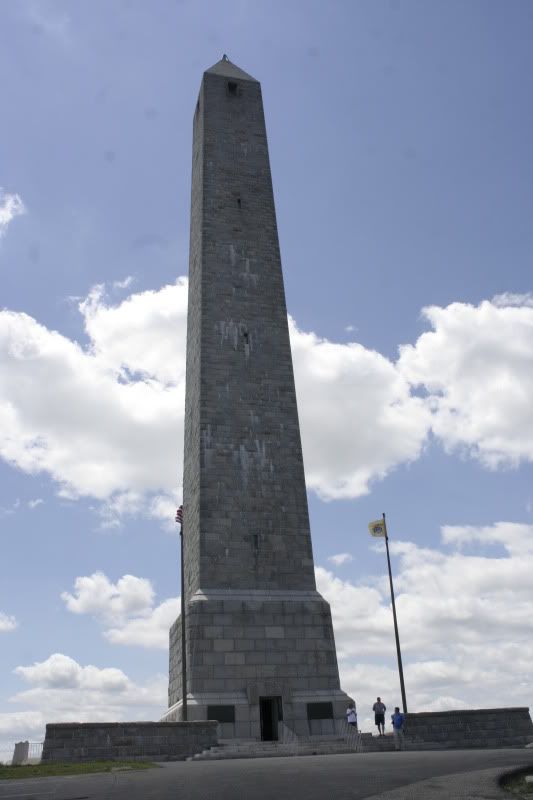
This is the monument at NJ's highest point, which also happens to be right near the northernmost point of the state too.
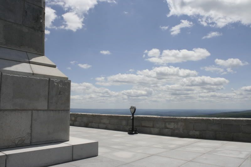
We really couldn't have asked for a better day, weather-wise.
34 more images below the jump - click any one to make it bigger in Photobucket.
Friday, July 30, 2010
Pictures 27: New Jerseyan Miscellanea
Pat and I spent about two weeks in New Jersey, so I have a few overhanging pictures that didn't really fit into any other category. So here they are.
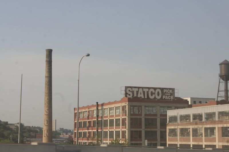


I very rarely get to ride over the Pulaski Skyway - I am usually driving - so it was quite a treat when my dad drove and I got to take pictures out the window of the urban landscape. Of course, the zoetrope-like railing didn't make for very good shots.

See? My dad drives. And Pat rides.
8 more pictures below. Click any one to see it bigger.
8 more pictures below. Click any one to see it bigger.
Pictures 26: Thomas Edison National Historical Park
A very awesome site in New Jersey that I had somehow never gone to before is the Thomas Edison National Historical Park. It includes the labs, prototype factory and home of Thomas Alva Edison, the relatively uneducated inventor who had a hand in inventing pretty much everything you use today, from the electric car to the modern movie studio. There are 1,093 American patents in his name.
Edison was a pretty cool guy, but he was also a bit of an obsessive genius. There is a little bed in his library that he would often use on overnight thinking sessions. He was constantly coming up with new things that could make life easier or, more often, would come totally out of left field and invent something we didn't know we wanted. When he was just a kid in Michigan, he started selling candy and vegetables, and soon became a relative expert at the telegraph. He'd amassed quite a fortune for himself by the time he moved to New Jersey, and he used his wealth to fuel inventing, and used the revenues from his inventions to fund more inventions.
Despite his total genius, he was a weird dude. Since childhood he had a severe hearing impairment, so he often felt awkward in social situations, unable to engage in much conversation. While he was working on prototypes of the gramophone, his horrid taste in music became clear; he often enjoyed shrill vocals and dissonant music because he could actually hear it. He was also stubborn - he worked in his labs until a few months before his death at age 84, and his employees had a personal elevator installed for him so he wouldn't have to climb the stairs. He refused to use it, however (despite a sign on it reading, "For Mr. Edison Only"), and climbed the stairs instead.
I'll babble a few more facts as we go through pictures. Patrick and I went to Edison's Labs on June 20, 2010.
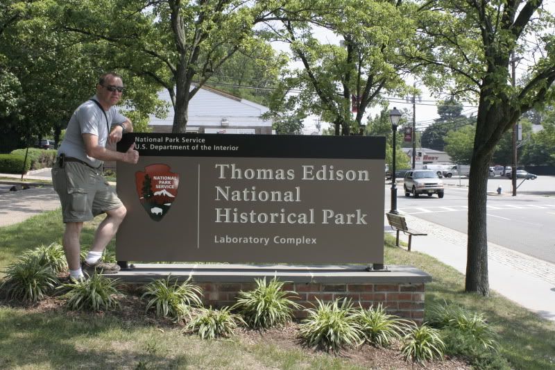
The thumbs-up!
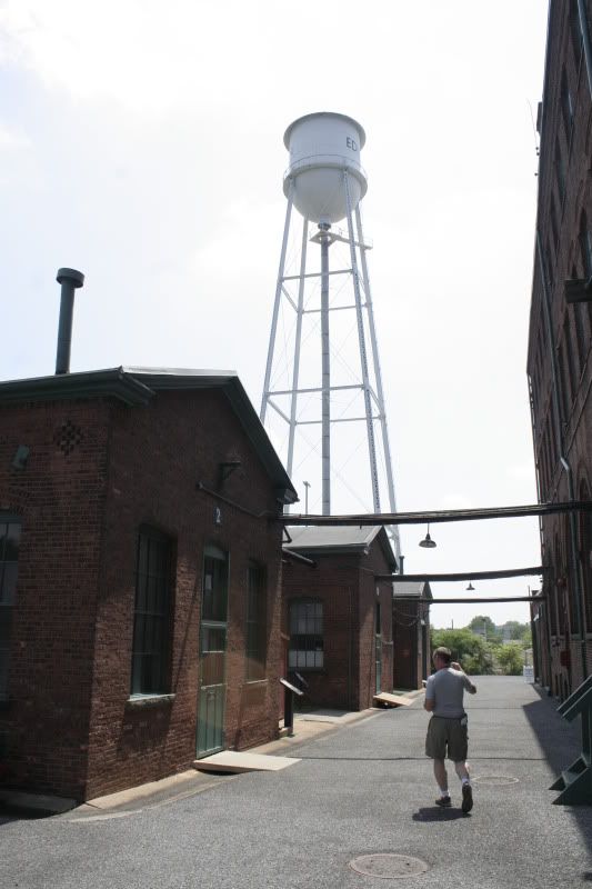
The area around the big brick buildings (which include the machine shop, library, chemistry lab, blacksmith, etc - everything needed to create any invention known to man, basically) is very cool, and feels like you're stepping back in time to when it was a bustling factory.
36 more images below! Click any one to see it bigger in Photobucket.
Pictures 25: The Statue of Liberty and Ellis Island
Backing up a little, getting caught up again on photo posts, we venture way back to June 15 to our jaunt into the Hudson to visit the Statue of Liberty and Ellis Island (which, if you want to get picky, are the Statue of Liberty National Monument and Ellis Island National Monument [part of the Statue of Liberty National Monument], both National Parks System sites in New York). Yep, they are part of the NPS, so we got to check a few more off our list of NPS sites to visit!
We decided to go on a weekday because we figured the crowds would be easier to handle - and while we were probably right in some regard, we made the sore mistake of choosing a weekday in June. Anyone with any experience with public schools in North Jersey will know that there are a few places notorious for being the destination of many schools' end-of-the-year field trip, and the Statue of Liberty/Ellis Island is one of them. (Various resorts in the Poconos are other top choices, as are art museums in the city and historic Philadelphia - and once I even went on a June field trip to Amish Country [Lancaster County, Pennsylvania], which was definitely the best end-of-the-year field trip ever.)
So while we missed the weekend crowds, we were inundated with hordes (no, seriously - hordes) of middle-school-age kids bouncing off the walls, screaming, running back and forth, and generally being obnoxious and terrible. I can understand the impulse of taking kids that age to Ellis Island, but you really would be better off taking kids of a high school age to the site - they would probably understand it better and actually read the trillions of text-based exhibits. The kids who were there seemed to have been given a scavenger hunt to find facts and information around the site, but they seemed to better enjoy running from clue to clue than actually learning about what they were finding.
That being said, the first two hours of our jaunt into the river was pretty rough, but once the school kids cleared out just after lunch time, things quieted down and we were left with mostly fellow adult tourists, which I can deal with much easier.
A few words to the wise about visiting the Statue of Liberty (which I always want to call "Shashoo Liberty" for some reason) - book your ferry tickets early, your pedestal tickets earlier, and your crown tickets months in advance.
You must take a ferry to get to Liberty and Ellis Islands, of course, but many people (including me!) don't realize that you need to advance-purchase tickets to the observation pedestal under the statue (they are typically sold out one to two weeks in advance), and if you want to climb all the way up to the statue's crown, those tickets need to be bought three to six months in advance. Crazy! I don't know why I didn't realize these things, but at least we were able to get ferry tickets online ahead of time.
So, without further a-blah-blah, here come some pictures. I am starting out with pictures from the visit my dad, Patrick and I took to Liberty State Park the day Patrick arrived in New Jersey.
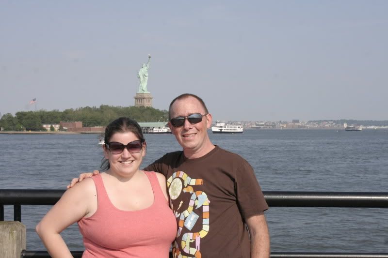
I like this one.
26 more images below; click any one to make it bigger in Photobucket.
Subscribe to:
Posts (Atom)